As mentioned in my first post on preparing a digital teaching project titled “Practical Preservation”, it finds its seed in the first historic building conservation course I had initiated as an elective in an architecture college in Mumbai, India, in 2006. This post is related to the course content not only in this previous post but also the structure I had prepared in the original regular teaching course. The fundamental difference in the 2006 and the 2023 course is that while I was onsite (in the classroom and on heritage sites) for the previous, it is not possible for me to conduct this in person this time round. Hence, the 2023 course is primarily conducted (by me) virtually with online components, and which would necessitate the students (architecture undergrads in their 4th year of study) to visit historic sites, archives and museums in the city, and other subject matter experts.
While going through my notes I found a basic structure for the Conservation Elective 2006 course. 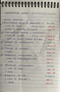
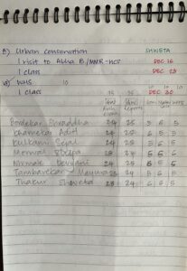
Hand-written and colour coded for students, requirements and dates, it is simplistic but the topics for 2023 Practical Preservation Series essentially remain the same. The 2006 version had an on-site class and a field trip, culminating in group presentations for each module. The 2023 version will have, within each module, again a site visit and several layers of digital tools to understand each component. Each module will also have a synchronous class meeting for presentations and discussions. Some of the digital tools that could be used for mapping are ArcGIS StoryMaps, which is a very user friendly tool to prepare a walking tour, and which could be used for Module 1 on Urban Morphology. I would also like the students to compile a database of archival photographs, maps, video recordings, documentaries, songs (and there are quite a few!) and other audio files on the city.
The second module on Architectural styles, further develops the walking tour to introduce building styles, typologies, construction dates and other historical data within the digital mapping tool. The Digital Harlem project could be shown as a parallel, along with the one devised for Mumbai by the Urban Design Research Institute (the later is not very interactive and kind of dry). HistoryQuest DC is another example that comes to mind. Interspersed with readings and field trips, each module is devised with a view towards introducing a different digital tool, primary resource, peer reviewed writing and other media. This varied, immersive, collaborative and derivative experience for each module using both traditional teaching method and digital tools will hopefully create multiple learning opportunities for students, thereby laying the ground for further investigative historical thinking applicable to other settings.
The unlimited potential of teaching using the medium of digital tools has made it possible to even think about this unthinkable (for me) concept of a virtual conservation course, which I had completely dismissed as being improbable before doing the digital certificate course. The ease with which historical data can be presented and interpreted with the help of digital resources has been the deciding factor to prepare the course work for this project.